Geocoding |
Learn more about Verizon Connect GeoBase.
Get information about the latest release
In GeoBase there are two types of geocoding: forward and reverse. Forward geocoding refers to the process of turning a street address into latitude and longitude coordinates. Reverse geocoding is the opposite of forward geocoding and is the process of converting latitude and longitude co-ordinates into street addresses. These two capabilities lie at the heart of the GeoBase system, allowing user input to be converted into real-world location information, and vice versa.
Verizon Connect GeoBase Map Explorer demonstrates geocoding by allowing users to enter street addresses into a location bar. The addresses are geocoded and automatically displayed on the main map.
To forward geocode in Map Explorer:
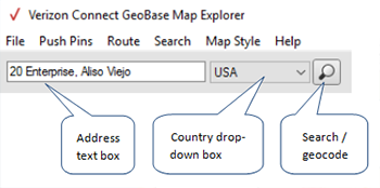
type an address into the address text box
select the country of the address from the country drop-down box
either press the Enter key, or click Search to the right of the country drop-down box.

Map Explorer responds in three ways to a geocoded address:
- the mini map highlights the general area of the address
- the main map zooms in, and centers itself on the address
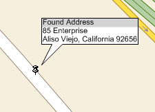
- a BalloonPushPin is added to the main map at the location of the address

If the address cannot be geocoded, then an Address not found pop-up will be displayed. If this occurs, ensure that the correct country has been specified, and then try adding more details to the address, such as region, or sub-region.
Reverse geocoding is demonstrated in Map Explorer by converting the position of the mouse, over the main map, to a physical address. To see this for yourself, hover the mouse over an area of the map, and note the reverse geocoded address on the left of the status bar. The corresponding latitude and longitude will also be displayed to the right of the status bar.

For more information about geocoding, the Geocoder class, and code examples, see the Geocoding Concept topic.